


In the scattered remnants of ancient stone structures lies more than craftsmanship—they bear the imprint of a forgotten dialogue between civilizations. These megaliths and pyramids, far from isolated wonders, suggest a shared vocabulary built on geometry and symbolism, a deliberate “language” crafted to preserve knowledge across time and space. This language speaks not only of architecture but of memory—memories encoded in stone that survive cataclysm, sea-level shifts, and the erasure of history.
What if these echoes are not random, but part of a deliberate, pre-cataclysmic blueprint, a “language” designed to transmit vital knowledge across epochs and even across continents?
Beneath this visible heritage runs a deeper current: the Atlantean Trace, a spectral blueprint of vanished continents and submerged civilizations whose echoes ripple through global myths and hidden geological records. This trace challenges the neat boundaries of traditional history, implying a web of ancient connections and transmissions that defy conventional timelines, perhaps even informing the very structure of the “language of stone” itself.
By examining these silent messengers of the past through the lens of early maritime exploration, including voyages such as those of Abel Tasman, we can glimpse how fragments of this ancient network may have guided human movement and understanding. In decoding these layered messages, we open a door to a premodern world where stone, sea, and memory converge—inviting us to rethink not only where we come from but how knowledge itself was preserved and passed on across the ages.

A stern view of the Dutch flute Zeehaen, left, and war yacht Heemskerck. This is a portion of an illustration from the journal of Abel Tasman, which detailed his 1642 voyage of discovery in the South Pacific. (PD)
See here, Abel Tasman’s fleet sighting New Zealand (1642)
The prevailing narratives of human history often adhere to a teleological progression, emphasizing documented milestones within Eurocentric frameworks of discovery and colonization. Such orthodoxies, while methodologically convenient, risk occluding the complexity and profundity of premodern global interconnections. Recent multidisciplinary inquiries suggest the necessity of reexamining this linear historiography through the prism of transoceanic cultural continuity, intelligence networks, and geological transformations that have profoundly shaped human settlement and memory.
This exploration proposes a reframing of early Pacific maritime ventures—particularly the voyages of Abel Tasman—as informed enterprises grounded not in serendipitous navigation, but in sophisticated intelligence gathering and the strategic pursuit of mineral wealth amid imperial rivalries. Furthermore, it situates the geological phenomena of Zealandia’s submergence and the cataclysmic formation of Lake Taupō within this historical context, suggesting these natural events are integral to understanding the remnants of advanced pre-cataclysmic societies. These societies, the essay argues, encoded their cosmological and navigational knowledge within monumental architecture, whose global distribution and architectural syntax merit renewed academic attention.
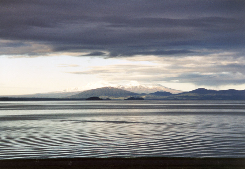
View of Lake Taupo, New Zealand, taken by Bo-deh~commonswiki in 2001 (CC-BY-SA 2.5).
See here, Lake Taupō, North Island, New Zealand — Artistic View by Eugene Ciceri. Before the Eruption (1886).Post Oruanui supereruption circa 26,500 years BP.
It is plausible to note that Tasman and other early voyagers obtained intelligence about New Zealand not only through intercepted European navigational data but also via indigenous knowledge shaped by the island’s dramatic geological history. The cataclysmic events, such as the Oruanui supereruption, alongside ongoing volcanic activity, would have left enduring marks on the landscape and collective memory. Such natural phenomena likely served as important signals of fertile land, mineral wealth, or navigational landmarks, transmitted through generations of oral tradition. This intersection of geological upheaval and human habitation could have provided explorers with strategic intel, demonstrating how natural disasters inadvertently contributed to the mapping and understanding of new territories, perhaps even echoing a deeper, shared knowledge of terrestrial shifts.
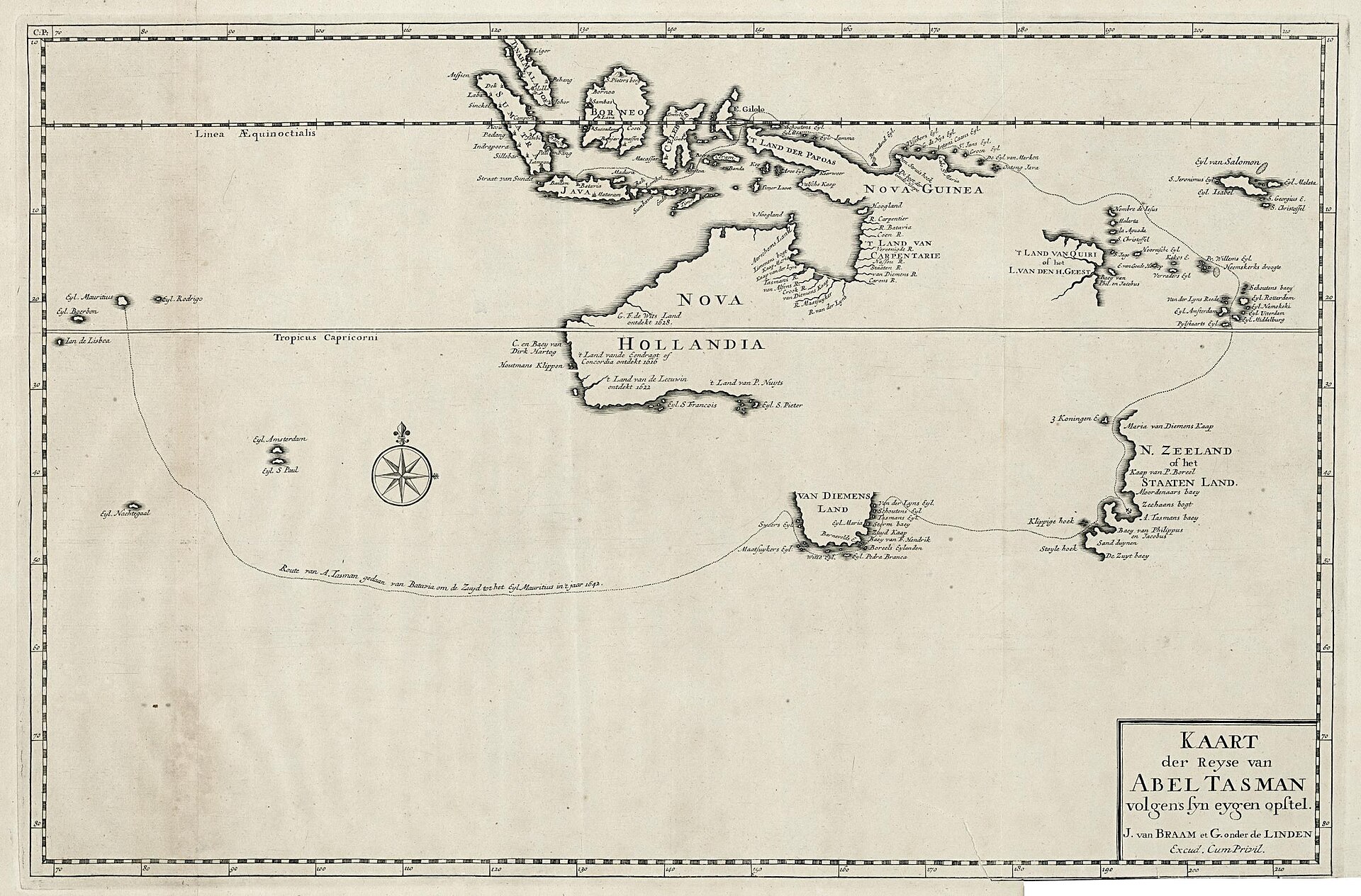
“Kaart der Reyse van Abel Tasman” (1726) by François Valentijn. (PD).
The Geopolitical Economy of the Early Modern Pacific: Intelligence and Resource Competition
The seventeenth-century Pacific theater was characterized by an escalating contest among European colonial powers, principally the Dutch, Spanish, Portuguese, and English, each vying for dominion over strategically and economically vital islands. Central to this competition was the acquisition of resources—precious metals, minerals, and spices—that underpinned mercantilist ambitions and military capacities. Control over Pacific archipelagos promised not only access to these resources but also critical maritime chokepoints that facilitated global trade networks.
Within this milieu, intelligence was paramount. Colonial enterprises deployed an array of espionage strategies: intercepting rival navigational charts, bribing informants within indigenous polities, and meticulously documenting coastal topographies. The Dutch East India Company (Vereenigde Oostindische Compagnie, VOC), a pioneering commercial-military hybrid, institutionalized intelligence operations as a core component of its maritime expeditions.
Abel Tasman’s voyages, commissioned by the VOC, exemplify this paradigm. Far from exploratory voyages conducted on a tabula rasa, Tasman’s expeditions were predicated upon accumulated, often covertly acquired knowledge. Historical records indicate Tasman’s crews actively engaged in intercepting Spanish and Portuguese cartographic data, deploying reconnaissance agents, and leveraging indigenous informants’ oral traditions. This intelligence convergence facilitated targeted navigation towards resource-rich territories, including the still poorly understood submerged continental fragment known today as Zealandia.

Logo of the Dutch East India Company (Vereenigde Oostindische Compagnie).
Source: Wikimedia Commons Vereenigde Oostindische Compagnie Monogram (PO)
Zealandia and the Geological Legacy of Cataclysm
Zealandia’s geological profile elucidates its profound impact on regional human histories. Emerging approximately 85 million years ago, Zealandia was largely submerged during the late Cretaceous and Cenozoic periods, with contemporary bathymetric studies revealing a largely submerged continent characterized by extensive continental shelves and terraces. Of particular interest is Lake Taupō, the caldera formed by the Oruanui supereruption circa 26,500 years BP, one of the most violent volcanic events in the Quaternary.
This eruption radically reshaped New Zealand’s physiography, reshaping coastlines and potentially disrupting indigenous settlement patterns. The intersection of geological cataclysm and human habitation necessitates a reconsideration of how pre-colonial societies might have transmitted knowledge of these transformations. The enduring oral histories and submerged geomorphological features indicate that the ancients possessed a sophisticated understanding of these phenomena—knowledge possibly preserved and clandestinely transmitted across generations, perhaps forming part of the “Atlantean Trace” of geological memory.
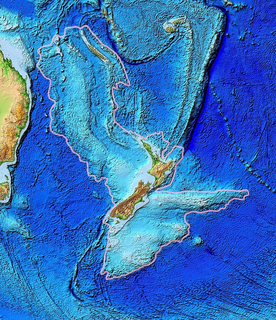
Topographic Map of Zealandia, the Submerged “Eighth” Continent. (CC0)
Monumental Architecture as a Global Epistemic Network
Beyond geological and historical considerations lies the architectural enigma of megalithic structures, whose global distribution and architectural congruencies suggest a coherent, transoceanic epistemic system. From the pyramidal complexes of the Andes, the Bosnian hills, and Egypt’s Giza Plateau to submerged structures such as Yonaguni and the Kaimanawa formation in New Zealand, these edifices exhibit precise geometrical alignments, astronomical orientation, and advanced construction techniques.
Such structures are conventionally interpreted as independent cultural phenomena; however, their shared characteristics—symmetrical geometry, cardinal alignments, and acoustic properties—indicate a universal language of monumental expression. This “architectural code” likely served multifarious purposes: navigational markers for maritime voyagers, cosmological observatories, repositories of esoteric knowledge, and perhaps even mediums for transmitting energy or information. It is here that the “Atlantean Trace” could be most evident—a common blueprint guiding their design.
The Kaimanawa formation, often dismissed as natural geology, merits reevaluation in this light. Its geometric regularity, spatial placement, and the regional context of Zealandia’s submergence suggest it represents a vestige of this global network, preserved as a fragmentary palimpsest of ancient maritime knowledge.
In 2019, a widely circulated video titled “Pre-Historic Mega Structure Discovered In New Zealand – Kaimanawa Wall” showcased two independent researchers using hand tools and soil probes to investigate the site. They reported discovering deeper stone layers and registering hollow sounds upon tapping the surface—suggesting the possibility of subsurface cavities or a buried extension of the structure. While these findings remain unverified by formal archaeological investigations, and many geologists maintain that the formation’s rectilinear features are the result of natural rhyolitic jointing in ignimbrite, the debate remains unresolved. Yet even within a natural geological framework, the Kaimanawa formation may hold cultural significance. It is plausible that either pre-cataclysmic settlers or early Māori communities recognized and utilized its unique geometry—repurposing the site for ceremonial, navigational, or strategic functions. In this context, the “wall” becomes not only a geological anomaly but a possible example of how pre-colonial communities encoded or adapted natural landforms into their cultural and spatial landscapes.
Across the globe, megalithic structures such as Stonehenge (England), Nabta Playa (Egypt), Chankillo (Peru), and the Carnac stones (France) have long been interpreted not just as ceremonial sites, but as sophisticated instruments of sky-watching and terrestrial navigation.
The 1740 work of antiquarian William Stukeley, often credited as one of the first to study Stonehenge through a proto-archaeoastronomical lens, posited that ancient builders deliberately aligned the stones with solstices and cardinal points. His observations laid the groundwork for understanding how ancient societies embedded navigational cues within sacred architecture.
In pre-literate or partially literate cultures, the alignment of stone monuments to celestial events like solstices, equinoxes, or the heliacal rising of stars served practical purposes:
- Calendrical functions for planting and harvest
- Directional orientation for overland and maritime travel
- Territorial markers tied to clan or tribal boundaries
- Encoded knowledge systems, passed via oral tradition and physical site features.
In this sense, these structures formed what could be described as an epistemic grid—a geospatial framework through which ancient peoples encoded knowledge about the land, the sky, and their place in the cosmos.
Relating This Back to the Kaimanawa Wall
The Kaimanawa Wall in New Zealand, whether natural, modified, or entirely human-made, should be re-evaluated within this global context. Even if its foundational layers are of natural origin, the presence of flat, block-like stone segments and acoustically hollow-sounding spaces—as reported in field footage from independent researchers (2020s)—suggests the possibility of adaptive reuse by early or pre-cataclysmic settlers.
If early Polynesian navigators, such as the Lapita peoples or proto-Māori explorers, encountered these formations, they may have incorporated them into their own landscape cosmologies—possibly as landmarks, ceremonial sites, or even as mnemonic anchors used in navigation.
The possibility exists that a network of natural and artificial formations—aligned to celestial events—functioned similarly to Stonehenge: as a kind of mariner’s compass and mythological
clock, guiding seasonal movement, trade routes, and oral histories across the Pacific and beyond.
The solstice-aligned orientation of structures such as Stonehenge underscores their utility beyond ceremonial purposes—positioning them as sophisticated tools of spatial awareness. These megaliths, with their precise geometrical construction and axial alignments, could serve as fixed celestial reference points, enabling ancient cultures to track time, establish seasonal cycles, and maintain consistency in overland or maritime navigation. The entrance of Stonehenge, aligned to the summer solstice sunrise, effectively operated as a cosmological compass, signaling directional bearings grounded in solar motion. As such, these monuments likely functioned as cardinal markers within a broader navigational grid—anchoring mythological, agricultural, and exploratory knowledge within stone. In this light, megalithic sites like Stonehenge may have contributed to a transoceanic system of wayfinding, employed not only by local inhabitants but potentially integrated into the reconnaissance strategies of later maritime explorers through inherited oral traditions or cross-cultural contact.
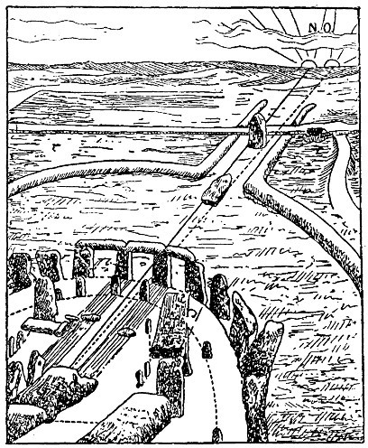
Plan of This diagram illustrates Stonehenge’s precise solar alignment, highlighting its function as an ancient navigational and calendrical marker integral to prehistoric wayfinding and timekeeping. Stonehenge Showing Solstice-Aligned Entrance and Structural Features. (CCBYSA4.0)
Tasman’s Expedition as an Intelligence-Driven Endeavor
Given this context, the traditional framing of Tasman’s 1642-43 expedition as an accidental or purely exploratory venture is untenable. Documentary evidence from VOC archives reveals that Tasman’s crews had extensive experience in intelligence operations, including:
- The interception and analysis of Iberian navigational charts and correspondence during maritime engagements.
- The systematic gathering of indigenous knowledge through strategic alliances and coercive diplomacy—perhaps specifically seeking information about significant landforms or resource locations known through generations of oral history.
- The utilization of reconnaissance and espionage to ascertain the location of mineral-rich territories and potentially significant archaeological sites.
This corpus of intelligence was essential for navigating toward the emergent knowledge of Zealandia’s submerged continental features and the enigmatic “upright geometric formations” referenced in indigenous narratives. Tasman’s voyage thus represents an early instance of empirically guided maritime exploration, informed by a confluence of espionage, ethnographic intelligence, and geological awareness—elements that may have been subtly guided by the enduring “Atlantean Trace” itself.
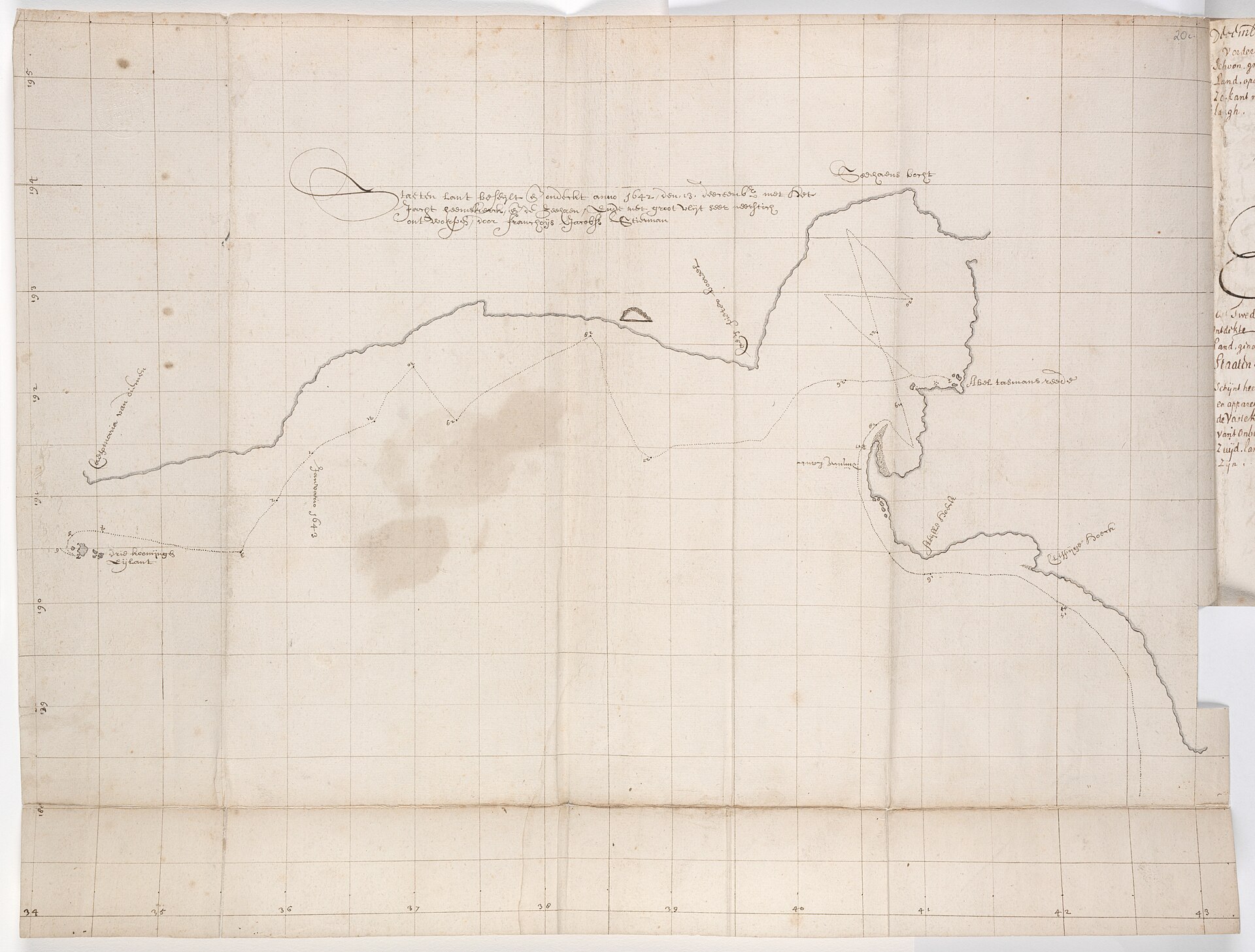
Chart of the north-west coast of the South Island, New Zealand, Huijdecoper journal of Abel Tasman, Hessel Gerritsz, 1643. (PD)
This map visually underscores the strategic imperative of Tasman’s intelligence-driven expedition: to fill the critical gaps in cartographic knowledge and uncover vital new passages.
Synthesis of Arguments: Towards a Holistic Understanding of Pre-Modern Global Knowledge Systems
Reassessing early Pacific exploration and monumental architecture through this interdisciplinary lens challenges prevailing historiographical paradigms. It foregrounds the sophistication of premodern intelligence networks and the profound interrelation between geological cataclysms and human cultural memory.
The global distribution of megalithic architecture, coupled with the intelligence-informed voyages of explorers like Abel Tasman, suggests an interconnected human history that transcends the linear narratives imposed by colonial historiography. This history is encoded not only in documents but in the very landscape—submerged continents, volcanic calderas, and monumental structures serving as silent yet eloquent testimonies.
This reconsideration invites scholars to engage with these interdisciplinary data points—archaeological, geological, historical, and ethnographic—to decode the “architectural Rosetta Stone” that might illuminate humanity’s shared ancient legacy.
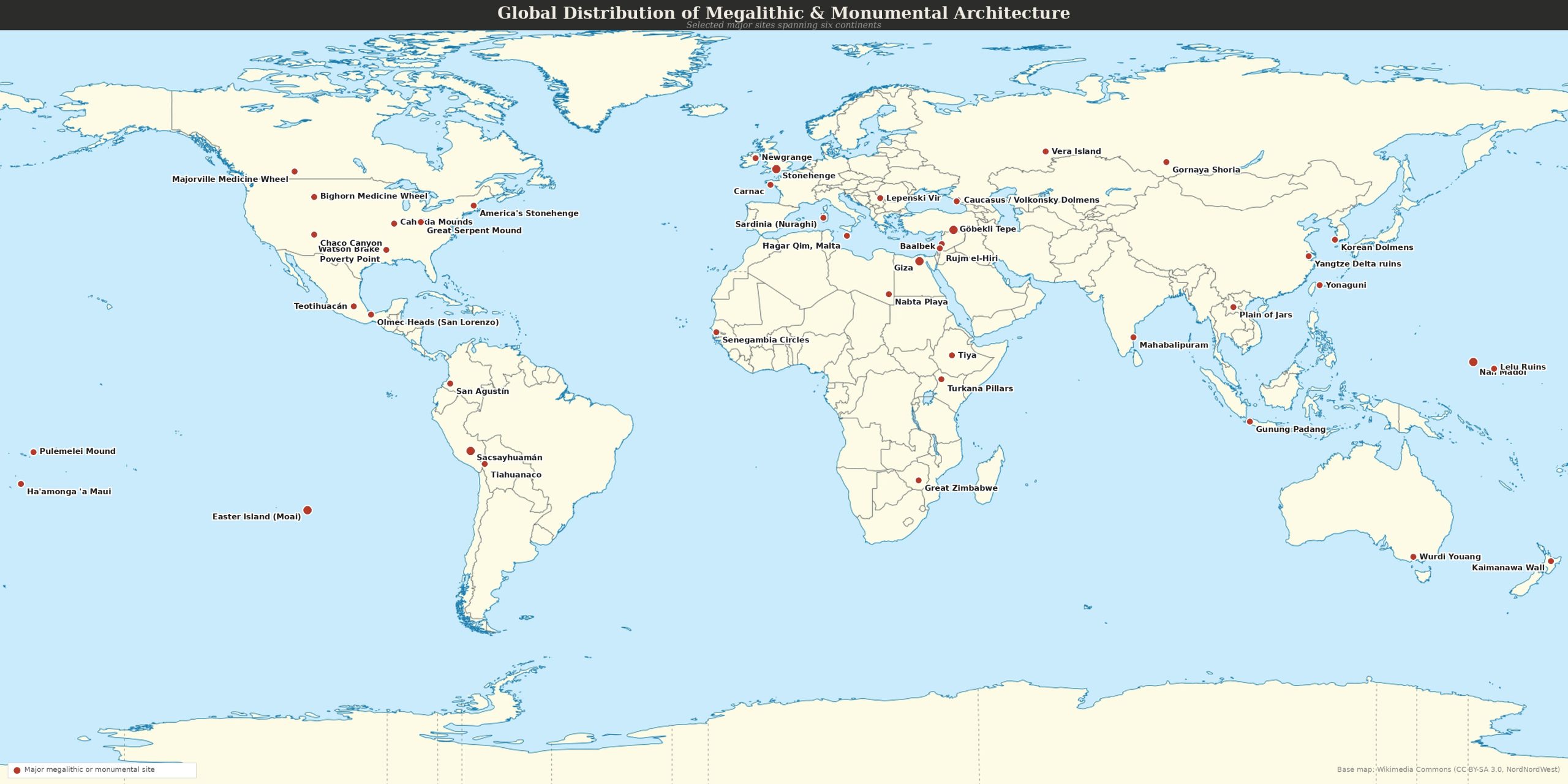
Global Megalithic Footprints: A Shared Ancient Legacy
Map by Leila Sarris. Base map: Wikimedia Commons (CC BY-SA 3.0, NordNordWest).
This map visually underscores the worldwide presence of monumental architecture, suggesting a profound and interconnected ancient human legacy that transcends geographical boundaries.
Conclusion: The Echo Beyond the Horizon
Perhaps history has always been more echo than record — a resonance from a past we scarcely understand, distorted by time, silence, and the careful curation of empire. In the voyages of men like Abel Tasman, we find more than just the ambitions of a maritime superpower or the lure of undiscovered trade routes. We see a man driven not only by duty but by the intoxicating pull of legacy — the possibility of entering history as one who charted the edge of the known world. Tasman, like others of his time, moved within a highly competitive, intelligence-driven theater, where Portuguese secrets, Spanish whispers, and long-guarded nautical knowledge filtered through rival courts and companies. His crew were no strangers to reconnaissance, interception, and adapting to fragmentary data. It is not unreasonable to imagine that their journey toward Aotearoa was informed by more than wind and chance — that it was shaped by inherited whispers of submerged lands, ancient monuments, and resources hidden in the folds of the Pacific.
But what if their journey — and indeed the journeys of many who came before and after — was more than geopolitical? What if they were unknowingly drawn to places where memory clings to stone and landmasses like Zealandia still haunt the ocean floor? What if the true voyage was toward a forgotten story, one not etched in parchment but encoded in ruins, in geomagnetic anomalies, in myths of sunken continents and colossal upheavals—a message from the “Atlantean Trace” itself?
We are not simply the heirs of empire, but of enigma.
And so, we must ask: Were explorers like Tasman chasing gold and glory? Or were they—perhaps guided by something older than maps—following the final, fading trail of a once-global intelligence, scattered by catastrophe and time? A message carved not into scrolls but into the Earth itself?
The past may not be dead. It may not even be past. It may be waiting—just beyond the next horizon.
With gratitude for your thoughtful consideration of this exploration. May the language of stone inspire your own quest for knowledge, guiding you to what lies just beyond the horizon.
Caleb-